
Less than two hours apart sit two answers to the same question — what does it mean to belong to a piece of land — and they could not be more different.
One is 726 feet of concrete holding back a river by force. The other is nearly a million acres held, by a people who have never stopped insisting the land owns them as much as they own it.
The drive out of Las Vegas empties fast. Within twenty minutes the strip’s density gives way to open desert, and by the time Hoover Dam comes into view, the contrast with the city behind you is already doing its work — neon and water shows traded for raw rock. Then the dam and the Tillman Bridge together — one dense, the other seemingly weightless — form a massive land bridge that feels simultaneously extruded from the rock and completely foreign to it.
Hoover Dam is, on its own terms, extraordinary. Completed in 1936, it rises 726 feet from bedrock, an Art Deco monument to the idea that a river could be told what to do. The dam is set directly into the canyon walls, curved against the pressure of Lake Mead behind it — the reservoir that the dam itself created, the largest in the country by volume when it filled, now the line separating Nevada from Arizona.
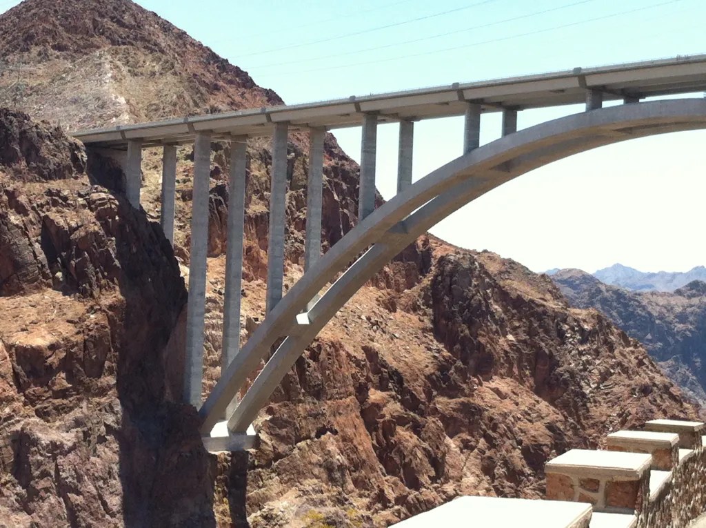
The Mike O’Callaghan–Pat Tillman Memorial Bridge, completed in 2010, carries the highway across the gorge in a single arched span, bypassing the dam’s old two-lane crawl and giving you, for a moment on the bridge, the dam’s entire scale at once: white concrete against red rock, water held flat and blue in a desert that otherwise offers nothing in that color at all.
We stopped at the overlook beneath the bridge to take in the dam and the lake — the scale of it settling in differently than it does from the road overhead.
This is engineering as control — a 20th-century conviction that the right structure, applied with enough concrete and enough ambition, could solve a river. It did, in the narrow sense: it tamed the Colorado, generated power for millions, made the growth of Las Vegas and much of the Southwest possible. What it also did, less visibly from the bridge, was submerge canyons, displace ecosystems, and fundamentally alter a river that had carved the Grand Canyon itself over six million years. Both things are true at once, and neither cancels the other out.


Into the Desert
From the dam, the road continues south on Highway 93 into a landscape that gets starker the farther you go — rolling hills giving way to Joshua trees and drought-tolerant scrub, the kind of high desert that looks empty until you slow down enough to see how much is actually living in it. At Dolan Springs, the highway gives way to a slower, 50-mile stretch toward Grand Canyon West, the land changing register again as you go: jagged mesas rising against flat ground, the red earth getting redder, a rugged final stretch of dirt road climbing into the backcountry toward the small airstrip that serves as the entry point.
By that point in the trip, Vegas had already tipped for us from fun and whimsical into something closer to excessive and superficial — the kind of place that wears out its own charm if you stay too long. I was ready for something more grounding, something that felt genuinely awe-inspiring rather than engineered to impress, and I wanted that lesson for our boys as much as for myself. You’ve gone from a landscape entirely subordinated to human engineering to one that has resisted it almost completely — not because no one tried, but because some land simply does not bend.


Grand Canyon West
Grand Canyon West sits on nearly a million acres of the Hualapai Reservation, on the canyon’s southwest rim — a different stretch entirely from the National Park’s more visited South Rim, and a place where the canyon is experienced specifically as Hualapai land, not generic wilderness.
Shuttles run from the small airport out to the overlook points, and the walk to the rim delivers the canyon the way it should be delivered: suddenly, without much warning, the ground simply falling away into a depth that photographs never quite communicate. Cracks running through the rock near the edge hint at how unstable the rim itself can be, a reminder to watch your footing rather than just the view.
At the rim, a Hualapai local told us to look for an eagle formed in the rock, wings fully outstretched, hidden in the joint where two sandstone formations meet — and once we found it, it was hard to unsee, the bird holding its shape in stone the way the real ones hold theirs riding the thermals below.


The Colorado River runs far below, a thin silver line that doesn’t look capable, from this height, of having carved everything around it — though of course it did, patiently, for longer than any human structure has existed or will exist. Late in the day, the river catches the angled light and the whole canyon shifts color with it, the red mesas deepening, shadows pooling in the folds of rock that the midday sun had flattened out.


Near the rim, several traditional dwellings are set up to represent some of the indigenous nations connected to this land and this region more broadly: a Hopi structure built of stone and mortar, a Navajo hogan — its log-framed dome covered in earth, its entrance deliberately facing east, toward the rising sun — and a Plains-style tipi, its poles once covered in bison hide and now in canvas.
Each represents a different relationship to shelter and to land, distinct traditions gathered here to give visitors some sense of the range of indigenous architecture across the region, even as the Hualapai themselves — whose name translates to People of the Tall Pines — are the ones whose land you’re standing on.
The Hualapai’s own description of this place captures something the dam, a couple hours back up the highway, never could: rolling hills, rugged mesas, breathtaking cliffs, ponderosa pine forests, deep gorges, and the wildlife that depends on all of it holding together.
Their relationship to this land isn’t recreational or even custodial in the way a park ranger might describe stewardship. It’s definitional. We are the land and the land is us. We are one and the same — not a slogan, but a worldview, and one that stands in direct and useful contrast to the dam at the start of this same drive.


What the Distance Between Them Asks
Hoover Dam and Grand Canyon West are roughly two hours apart, and yet they represent something closer to opposite ends of a spectrum than two stops on the same road trip. One is the 20th century’s confidence that engineering could master a landscape outright. The other is a people’s insistence that mastery was never really the goal — that survival depends on understanding yourself as part of the system rather than its operator.
Neither position is simple, and the honest response to a day spent moving between them isn’t to declare one correct. The dam has provided water and power to millions of people who now depend on it completely; undoing it isn’t a realistic proposition, whatever its ecological cost. But the Hualapai’s framework — land and people as inseparable, technology held in cooperation with environment rather than in command of it — is the kind of thinking that becomes more urgent, not less, the longer industrial-scale control of natural systems continues to reveal its limits.
This day trip away from Vegas’s bling was the grounding I’d been looking for — a philosophy built on interdependence and balance rather than dominance, and one I found myself hoping the boys were absorbing as much as I was.
The ecosystem holding both the dam and the canyon together is more complex than either human structure or human philosophy fully accounts for. Spend a day moving between the two, and that complexity stops being abstract. It becomes the particular kind of quiet you carry out of the desert with you, somewhere between the dam’s hum and the canyon’s silence — closer, by the end of the day, to the canyon’s.