
GOLDEN STATE
Larger than many countries, California extends between a range of the most extreme and diverse climates and terrains in the country. The highest peak drops to the lowest basin; mountain forests release to sandy beaches; prolific valleys surrender to desert expanses. California has it all.
This state also holds the largest state population with nearly 40 million people. Six urban areas sprawl with over 1.6 million people each: Los Angeles-Orange County, San Francisco-Oakland, San Diego County, Riverside-San Bernardino, Greater Sacramento, and San Jose-Santa Clara County.
California 12 Regions by Counties
Note: Counties are simplified into their primary geographic regions, designations for comprehensive clarity, although several counties share multiple regional aspects.

Northern California
Del Norte + Humboldt + Mendocino + Lake + Sonoma (Bay Area) + Napa (Bay Area)
Siskiyou + Trinity + Shasta + Modoc + Lassen
Plumas (Cascade) + Sierra + Nevada + Placer + El Dorado + Amador + Calaveras + Tuolumne + Mariposa
Sacramento + Yolo + Colusa + Sutter + Yuba + Butte + Glenn + Tehama
Central California
San Francisco + Marin + Solano + Contra Costa + Alameda + Santa Clara + San Mateo
Santa Cruz + San Benito + Monterey + San Luis Obispo + Santa Barbara + Ventura
San Joaquin + Stanislaus + Merced + Madera + Fresno + Kings + Tulare + Kern (Deserts)
Alpine + Mono + Inyo (Deserts)
Southern California
San Bernadino (West Inland Empire + East Deserts) + Riverside (West Inland Empire + East Deserts) + Imperial (Deserts)
(East Deserts)


Getting Around
Many airports exist throughout the state, but LAX in Los Angeles and SFO in San Francisco remain the primary hubs for international air travel. Rail options continue to be limited through California. Mostly unsophisticated regional transit can be found in some urban centers, although San Francisco’s BART, which connects to SFO, and the Bay Area’s ferry system prove to be the most useful.
Cars continue to be the primary form of transport and thus contribute to the notorious urban traffic congestion but also allow for epic road trips using the state’s vast highway network.
Epic Highway Routes

Pacific Coast Highway

The Pacific Coast Highway offers epic views along the length of the Pacific coast from Puget Sound in Washington (where it split from I-5 in Olympia) to San Diego. California’s PCH combines Highway 1 with The 101, which runs through the state from Del Norte County’s border with Oregon and I-5 in Los Angeles.
Narrow Hwy 1 (the PCH) showcases the most glorious vistas as it hugs much of the rugged coastline from Mendocino County where it initially splits from the 101, rejoining it periodically in Marin to San Francisco, San Luis Obispo, and Santa Barbara to Ventura County where it again splits off between Oxnard and Dana Point in Orange County. From here, I-5 takes over on the way to San Diego County, then the Coast Highway picks back up along San Diego‘s northern beachside towns between Oceanside and La Jolla where it rejoins I-5.
Central Valley Corridor
The notorious Interstate 5 corridor (CA I-5) provides the fastest route through the length state and completes the connection between the US international borders from San Diego County at Mexico through Siskiyou County at the north end where it extends north through Oregon and Washington west of the Cascade Mountains to Canada.
This I-5 thoroughfare splits the Central Valley on the western side with the original (and more appealing) Golden State Hwy 99, once California’s Main Street, along its eastern side from Tehama County to Kern County, briefly rejoining through Sacramento.
Transcontinental Spans
I-80 connects San Francisco to Sacramento and across the Sierra-Nevada Mountain Range to Truckee in Nevada County (North of Lake Tahoe) through Nevada at Reno and beyond, all the way to the greater New York City as it traverses the entire country through Utah, Wyoming, Nebraska, Iowa, Illinois, Indiana, Ohio, Pennsylvania, and finally New Jersey.
Historic Hwy 50 also traverses the country, branching from I-80 in Yolo County at West Sacramento to the Nevada. It provides the main east-west access through the state capital of Sacramento County, once a stagecoach route through Folsom into the foothills. This scenic route meanders through El Dorado County’s Placerville in its historic gold country—now more known for wine and apples—across its Sierras along the South Fork American River Canyon, rising high up to capture spectacular views from Echo Summit before dropping down to South Lake Tahoe where it wraps into Nevada along the southeast shore of the lake, through Carson City stretching across the nation to Ocean City, Maryland.
I-10 stretches from Santa Monica at the Pacific Ocean in LA County to Arizona, where it proceeds across the country through New Mexico, (San Antonio) Texas, and the Deep South all the way to (Jacksonville) Florida on the Atlantic Ocean. San Diego connects through Imperial County via I-8 to Arizona and continues east where it joins I-10 between Phoenix and Tucson.
San Diego also connects through San Bernardino County via I-15 to Nevada and extends north to Canada through Utah, Idaho, and Montana. I-40 crosses the desert from I-15 at Barstow in San Bernardino County to Arizona and continues to span the US through New Mexico, Texas, Oklahoma, Arkansas, and Tennessee, ending in North Carolina at the Atlantic Ocean.
Lake Tahoe Loop

This drive around the lake starts from Hwy 50 in South Shore, South Lake Tahoe on the California side, dips into Nevada along the east side, making sure to take Hwy 28 around the north shore, stopping at Sand Harbor before returning to California, continuing onto Hwy 89 through King’s Beach and Tahoe City, stopping for the view at Emerald Bay, and can be made in the reverse direction. An option is to start at Hwy 89 from I-80 at Truckee north of the lake, which drops into Tahoe City. The map below shows the main points of interest along the way.
East Desert Route

Hwy 395 spans the arid eastern state from Modoc County in the north, extending northward to Canada as it continues through Oregon and Washington, entering Nevada north of Reno at Sierra County, and reenters California at Topaz Lake where it continues southward past Mono Lake below a wall of the towering Sierra-Nevada Mountain Range toward I-15 in San Bernardino County at Hesperia.
Hwy 190 branches off from Hwy 395 at Lone Pine under Mount Whitney, the highest point in California (but just one along a range of several soaring peaks over 14,000 feet high), toward the lowest in Death Valley.
Majestic Mountain Roads
North of Lake Tahoe
Hwy 89 extends north from Hwy 395 near Topaz Lake through the Sierras, crossing Hwy 50 to hug the west shore of Lake Tahoe with an awe-inspiring view over Emerald Bay to Tahoe City. The road continues northward, crossing I-80 at Truckee then Hwy 49 before temporarily joining Hwy 70 through Plumas National Forest until the junction near Indian Falls. The Sierras then give way to the Cascades (The Cascade Range extends from here into Canada), curves around Lake Almanor and Mount Lassen, and through the Shasta-Trinity National Forest to join I-5 at Mount Shasta.
Hwy 70 also extends from Hwy 395 at Beckwourth Pass, the lowest pass through the Sierras near the Nevada border, to Graeagle where it temporarily joins Hwy 70 through Plumas National Forest around Phantom Falls at Table Mountain near Lake Oroville, running along the Feather River past Sutter Buttes and Yuba City until reaching its junction at Hwy 99.
South of Tahoe Sierras
Hwy 4 stretches the width of California from I-80 at San Francisco’s East Bay in Contra Costa County, running along the confluence of the Sacramento and San Joaquin Rivers and The Delta that spreads through San Joaquin County toward Stockton, crossing I-5 and the city center into the foothills through Angels Camp and Murphys in Calaveras County, leading into the Sierra-Nevadas through Calaveras Big Trees, onto Bear Valley and Alpine Lake in Alpine County, and finally terminating at Hwy 89 near the Nevada border on the range’s eastern edge.
Hwy 88 travels from Stockton in the San Joaquin Valley through Amador County through the High Sierras along the Carson Pass by Kirkwood Ski Resort, finally crossing Hwy 89 as it drops into Nevada before its junction at Hwy 395 just south of Carson City.
Gold Country Trail
Hwy 49 is known as the Golden Chain Highway to honor the 49ers of the 1849 Gold Rush since it passes through many of the mining communities. The road travels from its junction with Hwy 70 in Plumas County through Sierra County at the north end of the Tahoe National Forest in Sierras to Oakhurst at the Hwy 41 junction in Madera County.
South of Sierra County, the journey winds across several counties through some of the best-preserved historic towns:
- Nevada City in Nevada County
- Auburn in Placer County
- Coloma (the original site of gold discovery) and Placerville in El Dorado County
- Plymouth, Amador City, and Sutter Creek (take Old Hwy 49) in Amador County
- Angels Camp in Calaveras County
- Sonora near Columbia State Historic Park in Tuolumne County
- Mariposa near Yosemite Valley in Mariposa County
- Oakhurst in Madera County
Epic Central Treks to High Sierra Canyons

Yosemite Routes
Hwy 41 crosses the middle of the state from Morro Bay near San Luis Obispo, through the vineyards and olive groves of Paso Robles, intersecting I-5 at Kettleman City, crossing the San Joaquin Central Valley to Fresno. Continuing north into Madera County the highway passes Coarsegold, home of the Chukchansi Tribe, which goes into the Sierras and through Oakhurst, ending at the south entrance into Yosemite National Park in Mariposa County. From here, Wawona Road winds its way to the Wawona Tunnel view over Yosemite Valley before descending into the epic site.
Hwy 140 first traverses the wide San Joaquin Central Valley from I-5 in Merced County before finally entering Mariposa County, climbing into the Sierras through Mariposa, winding toward its end at El Portal Road leading to the central entrance of Yosemite Valley.
Hwy 120 leads across prolific San Joaquin Central Valley from I-5 just south of Stockton in Manteca, through Oakdale in Stanislaus County, into the Sierras switching between Tuolumne and Mariposa Counties to the north entrance of Yosemite Valley at Big Oak Flat Road, continuing through upper Yosemite National Park, crossing Hwy 395 east of the mountain range at Mono Lake, ending in arid Mono County at Hwy 6 on the Nevada border.
Giant Sequoia & Kings Canyon Routes
Two main routes link to each end of Generals Hwy winding through Sequoia & Kings Canyon National Parks: Hwy 180 and Hwy 198.
Hwy 180 starts as a country road in the middle of the vast, prolific San Joaquin Central Valley. The route travels east, crosses Hwy 99 in Fresno before climbing toward the north access to Generals Hwy through the Giant Sequoias, meanders between towering peaks in Kings Canyon where the road ultimately ends at the Copper Creek trailhead in the Sierras. Hwy 152 creates a link from Hwy 1 at Monterey Bay in Santa Cruz County crossing the Coastal Range and Merced County in the Central Valley ending at Hwy 99 north of Fresno.
Hwy 198 starts at Hwy 101 in Monterey County, crosses the Tulare Basin of the Central Valley and ends at the south end of Generals Highway, which continues into Sequoia National Park.
Iconic Historic Route

The romance of Route 66 remains long after being bypassed in favor of more efficient high-speed interstate highways. The mystique calls to travelers wanting to experience the scenery and small towns between Santa Monica, California and Chicago, Illinois. Along the way across California the old route passes Beverly Hills, Pasadena and San Bernardino then taking the Cajon Pass through the mountains before crossing the Mojave Desert toward Lake Havasu on the border with Arizona.
Heritage and Quality
California is known to be a land of great opportunity. With that comes great responsibility. Many work to maintain traditional craftsmanship and artistry, search for methods to better align with the environment, and uphold high-quality standards to foster diverse communities.
The best cities and towns maintain a connection to and harmony with nature and are pedestrian and bicycle-friendly. Interconnected paths reduce traffic and link neighborhoods to gathering spaces and shops to encourage people to safely walk and bike, allowing people to work, shop, and find entertainment within their community.
A Brief History
Native and Missions
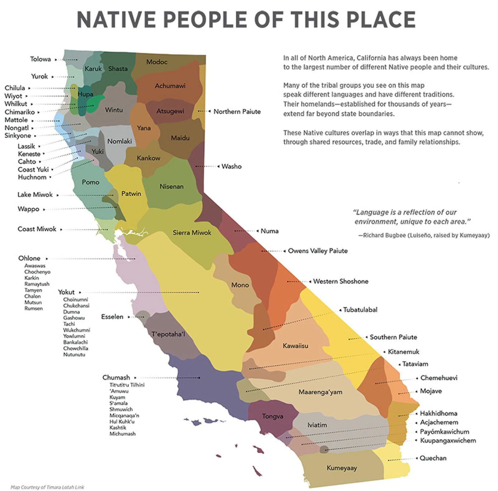
Over 300,000 natives from a multitude of tribal groups, each with an understanding and respect for the ecosystem, lived on and cared for the land. They are known to have worked in harmony with the natural world applying their advanced knowledge of plant use for traditional ecological medicine—how to use them, when to harvest them, and how much to take.
As Spain’s colonization moved northward, beginning in 1769 at San Diego de Alcalá, Fr. Junípero Serra founded the first nine of 21 Franciscan Spanish Missions to establish the church and convert natives to this order of Christianity. Following the War of Independence from Spain, Alta California, as it was called, became a Mexican territory.

The Gold Rush
In 1847, during the Mexican-American War, California was ceded to the US by Mexico, then became the 31st state in 1850. During this time, while building a sawmill on the American River’s South Fork in Coloma for Swiss immigrant Johann Sutter, carpenter James W. Marshall discovered gold.
The result was The Gold Rush, the mass migration of 1849, when prospectors from all over (including many Chinese) flooded the region in search of wealth. This tumultuous period that ensued inflicted great suffering upon the native Nisenan people of this region, other indigenous tribes throughout the state, and the environment they all stewarded.
San Francisco, Sacramento, and Stockton soon became centers for commerce. The economy boomed through land exploitation as more invasive methods were devised. Development in California continued, and the state has since attracted many in search of a better life. Suburban expansion continues to swell into virgin and agricultural land. Important collective efforts work to protect nature’s fragile beauty from adverse environmental effects caused by untamed development, pollutants, and natural and human destruction.
Expansive Landscape


Pacific Coast

Sand and Surf
The Pacific coastline of California stretches for 840 miles, with climates ranging from cool temperate to arid desert to subtropical. Its long-spanning shoreline varies between sandy beaches, natural bays, and rugged cliffs, which attract a variety of marine life and birds, as well as beach lovers and surfers.
Along the coastline from the south, beach communities radiate artistic, casual vibes such as Coronado in San Diego, Laguna Beach in Orange County, South Bay and Santa Monica in Los Angeles, Santa Barbara, Pismo Beach in San Luis Obispo, Capitola near Santa Cruz, and Half Moon Bay and Bodega Bay in the San Francisco Bay Area.
Discover abundant sea life at the Aquarium of the Pacific in Long Beach, Monterey Bay Aquarium, and Aquarium of the Bay on Pier 39 at Fisherman’s Wharf in San Francisco. Drive up the PCH (Pacific Coast Highway) to capture spectacular views at the Hearst Castle in San Simeon, Big Sur, 17-Mile Drive by Pebble Beach next to Carmel-by-the-Sea, and Mendocino.
Environmental Note
Southern Californian beaches are vulnerable, particularly in winter, to natural petroleum seeps that degrade into tarballs that often wash onto the shores, removed by beach-cleaning machinery. On the other hand, the biggest environmental threats to the water quality, wildlife, and residents are from off-shore oil drilling spills, watershed pollutants, and climate change.
The California Coastal Conservancy works to protect and restore natural and scenic beauty. They work with many partners to preserve “hundreds of thousands of acres of wildlife habitat, coastal farmland, and scenic open space.”
Central Valley

Prolific Valleys
The Sacramento River flows south from the Klamath Mountains through Lake Shasta, while the San Joaquin River runs north from headwaters high in the Sierra Nevadas. Both conjoin at the state’s center to enter San Francisco Bay. These two largest of the valley tributaries flow through a large inland depression of terrain spanning the center of the state, around 450 miles long and up to 60 miles wide. This flat Central Valley is abundant with agriculture, one of the most productive valleys in the world, growing half of all US-grown produce and nuts.
Strategically located at the confluence of the Sacramento River and the American River, the California capital city of Sacramento connects to the San Francisco Bay via the Sacramento River. This city was established as an agricultural community at Sutter’s Fort but transformed into a trade and mining center during the Gold Rush.
Mountain Forests

Coniferous Giants to Rugged Peaks
Massive Sequoias and Redwoods fill forests of the mountainous terrain of the coastal ranges and California’s largest mountain range, the Sierra Nevada Mountains. This range thrusts upward between the large Central Valley to the west and the Great Basin and Range to the east.
Some of the most spectacular natural wonders are found in and around the Sierras, including Lake Tahoe and the magnificent Yosemite Valley, within a few hours’ drive of each other. Further south, Mount Whitney ascends among the highest peaks, and nearby, to its east, the land descends to the depths of Death Valley below—respectively these are the highest and lowest points in the contiguous United States.
Mount Shasta rises up over 14,000 feet as a monolithic peak at the southernmost end of the Cascade Range. The mountains are perfect for skiing in winter or escaping the extreme heat of the valley in the summer.
Deserts

Badlands
Three main deserts are found in California. The Colorado Desert, the westernmost part of the larger Sonoran Desert of Arizona and northern Mexico, includes the Salton Sea and Joshua Tree National Park.
The soaring Sierra Nevadas create a rain shadow for the Great Basin Desert, which extends across Nevada and is filled with sagebrush. This high desert gives way to salt flats in the even drier Mojave Desert to the south. In 2 hours, you can drive from Mount Whitney, the highest point in the continental US to its lowest point, Death Valley, in the Mojave Desert.
Palm Springs Aerial Tramway
Historic Sites

History Preserved
Native tribes lived throughout California for centuries before the arrival of Spanish conquistadors. Indian Grinding Rock preserves the limestone outcropping use to grind acorns along with traditions and structures of Miwok people.
Following them came Franciscan missionaries who established missions along the coastline for religious conversion of the indigenous peoples. Between San Diego and Sonoma, 21 Spanish missions maintain the history of the Spanish conquests established by Junípero Serra in the 18th century. Mission Santa Barbara is the queen of them all, although Mission San Juan Capistrano is another top favorite.
After the Mexican-American War ended in 1848, California fell to the United States just before the discovery of gold. Coloma preserves its ghost town and lumber mill on the site of the first discovery that led to the Gold Rush. Old Sacramento and nearby Sutter Fort were established as trade centers during the subsequent Gold Rush. Fort Mason in San Francisco was established during the Civil War for coastal defense.
Gold Country

Eureka!
Native tribes called this land home for centuries. Indian Grinding Rock State Historic Park preserves the life and heritage of the Miwok people. The Chukchansi tribe of the indigenous Yokuts People is headquartered in Coarsegold, where prospectors found gold in 1849.
Along Highway 49, named for the rush of miners (49ers) who flooded the area in 1849, are old mining settlements. The El Dorado county seat of Placerville was founded near Sutter’s Mill, the original site where gold was discovered in Coloma. Other towns worth visiting are Auburn and Nevada City in Placer County, Sutter’s Creek in Amador County, and Columbia, Sonora, and Jamestown in Tuolumne County.
Quaint, rural towns and protected landscapes continue to offer a quiet respite and connection to nature. Many maintain local heritage and history, which combined give them a depth of character.
Wine Country

Fruitful Foothills
The valleys meet undulating hills with orchards and vineyards. Napa and Sonoma Valleys have achieved worldwide acclaim in wine production. There are other regions throughout the state, such as Santa Ynez Valley near Solvang and Shenandoah Valley near Plymouth, producing wonderful varietals.
In addition to wine grapes, farms in the hills grow tree and vine fruit, pumpkins, and Christmas trees. Apple Hill is known in the Sierras for apples and cider, along with wineries, pie varieties, and fall crafts and festivals.
Urban Centers

Megalopolis
As immigrants flooded the region during the Gold Rush and throughout the 20th century, vibrant urban centers began to form. The largest among them were San Diego, Los Angeles-Orange County, and the San Francisco Bay Area. Today these cities have spread into major metropolises, not only sprawling with congestion but rich with cultural diversity and connection to the world.
California truly is a state that offers something—and somewhere—for everyone.
Read More
All About California

Yosemite Spring
After California’s wettest winter on record, Yosemite Valley ran louder than usual — every fall at full volume, granite walls disappearing into mist, a rainbow waiting at the end of it. A spring trip through rain, the Ahwahnee’s fireplaces, and a detour to a fig-tree kitchen in Gold Rush country.

Mission San Juan Capistrano and the Pattern That Built a Coast
San Juan Capistrano holds the ruins of the Great Stone Church alongside the state’s oldest building still in use — a single site where the mission system’s architectural formula, and its human cost, are both fully legible. The same quadrangle logic repeats from Sonoma to Santa Barbara, and echoes once more, without the mission itself,…

Hearst Castle: The Discipline Behind the Excess
Hearst Castle is 165 rooms of Spanish Colonial, Moorish, Gothic, and Neoclassical detail, built over 28 years by the same architect who designed two buildings I’ve walked past my whole adult life in Sacramento. A family stop along the PCH, and a quieter return fourteen years later.